About CycleStreets journey planner
UK-wide cycle journey planner CycleStreets on your mobile device! Cycle journey planner for cyclists, by cyclists. Plan routes from A to B anywhere in the UK, with a choice of three routing modes to suit a range of...
UK-wide cycle journey planner CycleStreets on your mobile device! Cycle journey planner for cyclists, by cyclists.
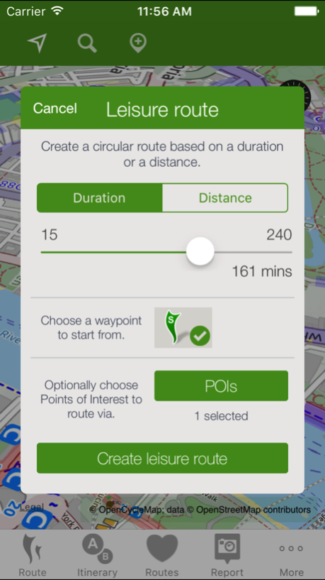
Plan routes from A to B anywhere in the UK, with a choice of three routing modes to suit a range of cyclists from beginner to regular commuter, plus a circular leisure routing mode. And the Photomap lets you submit photos of infrastructure problems or good practice around the UK.
PLAN CYCLE ROUTES FROM A TO B (TO C, D, ..)
Select a start and finish point by clicking on the map, by searching for names/places/postcodes, or by using your current location, and click to obtain the route.
CHOICE OF THREE ROUTING MODES
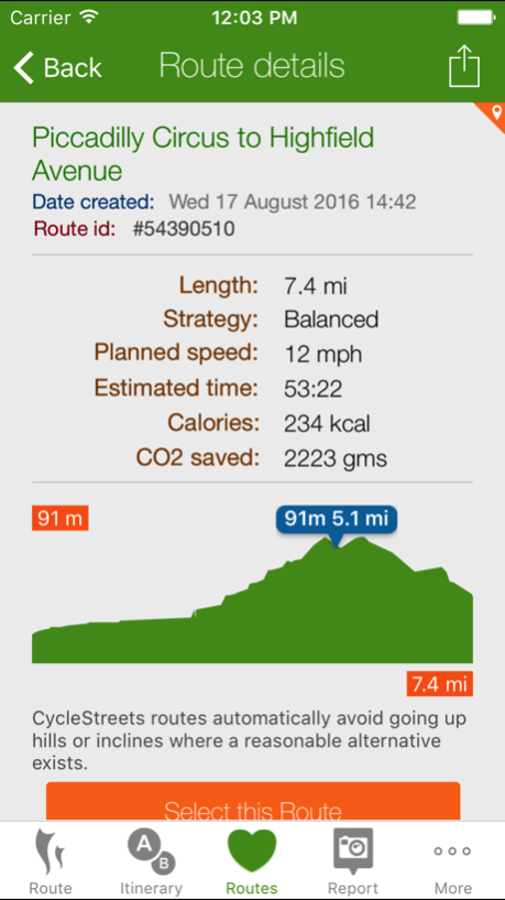
The app produces routes that will suit most cyclists. It can optionally can find faster or quieter routes for different types of rider. Routes are fetched from the CycleStreets website. You can switch the route type after planning it, and can save and rename and organise routes.
HILLS? NO PROBLEM!
The journey planner knows about hills, and finds routes that take advantage of the descents and avoids the ascents where possible. It balances these against the available road types. The route can be displayed on a map with contours using the OpenCycleMap option.
STAGE-BY-STAGE ITINERARY
As well as the main map view, planned routes are loaded into an itinerary view, so you can follow each part of the journey. The street name, time and length are all shown, as is a detailed map for each individual stage of the journey. Routes are saved so you can also follow them again later.
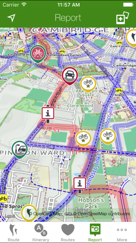
PHOTOMAP
The Photomap is a cycling advocacy tool used by campaign groups around the country. Use it to browse examples of problems or good practice, and add your own pictures. Need more cycle parking in your favourite spot in town? Sign in with a free account and add a photo of it to the Photomap.
OPENSTREETMAP
Routing makes use of OpenStreetMap data, the brilliant 'geo-wiki' to which you can contribute. Note that, at present, some areas of the country have better coverage than others. Streets and paths of all kinds, including Sustrans routes and Local Authority network, are included. Routing quality is being developed all the time, with new types of cycling and street data being added and interpreted by the route planner.
Thanks to Neil Edwards for his hard work on this release.
Oct 2, 2017
Version 3.2.6
This app has been updated by Apple to display the Apple Watch app icon.
• This release adds iOS 11 support.
• Vastly improved location search results and expanded search support.
• Search also now supports natural language queries like 'coffee shops' or 'cash machine'.
• Fixes an issue with location searching for postcodes where a space was included.
• Added new map tile servers for quicker map loading.
We're working on a bigger redesign and would welcome your suggestions - see our blog!
Previous Versions
Here you can find the changelog of CycleStreets journey planner since it was posted on our website on 2023-09-05 23:45:48.
The latest version is 3.2.6 and it was updated on 2024-04-23 09:54:27. See below the changes in each version.
CycleStreets journey planner version 3.2.6
Updated At: 2017-10-02
Changes: Oct 2, 2017
Version 3.2.6
This app has been updated by Apple to display the Apple Watch app icon.
• This release adds iOS 11 support.
• Vastly improved location search results and expanded search support.
• Search also now supports natural language queries like 'coffee shops' or 'cash machine'.
• Fixes an issue with location searching for postcodes where a space was included.
• Added new map tile servers for quicker map loading.
We're working on a bigger redesign and would welcome your suggestions - see our blog!
Disclaimer
Official App Store Link
We do not host CycleStreets journey planner on our servers. We did not scan it for viruses, adware, spyware or other type of malware. This app is hosted by Apple and passed their terms and conditions to be listed there. We recommend caution when installing it.
The App Store link for CycleStreets journey planner is provided to you by apps112.com without any warranties, representations or guarantees of any kind, so access it at your own risk.
If you have questions regarding this particular app contact the publisher directly. For questions about the functionalities of apps112.com contact us.